Jomiso harnesses decades of technical and engineering expertise to challenge conventional methodologies and redefine paradigms in water resource management. The organization unites a collective of seasoned professionals dedicated to tackling pressing water challenges. These challenges include shortages, pollution, droughts, floods, and the surging demands of urbanization. As these issues intensify, the scarcity of clean water increasingly hampers regional economic and social development. In turn, this necessitates immediate and decisive action.
With a comprehensive grasp of the entire water value chain, Jomiso delivers precise consulting and engineering services across key areas like water resource development, disaster management, environmental stewardship, and urban planning. The team at Jomiso, composed of hydrogeologists, hydrologists, and environmental specialists, collectively brings over 50 years of experience to bear on complex, mission-critical projects.
Jomiso’s success stems from its deep-rooted engagement with local communities, ensuring the solutions it provides are not only sustainable but also have a direct, positive impact without compromising essential ecosystems.
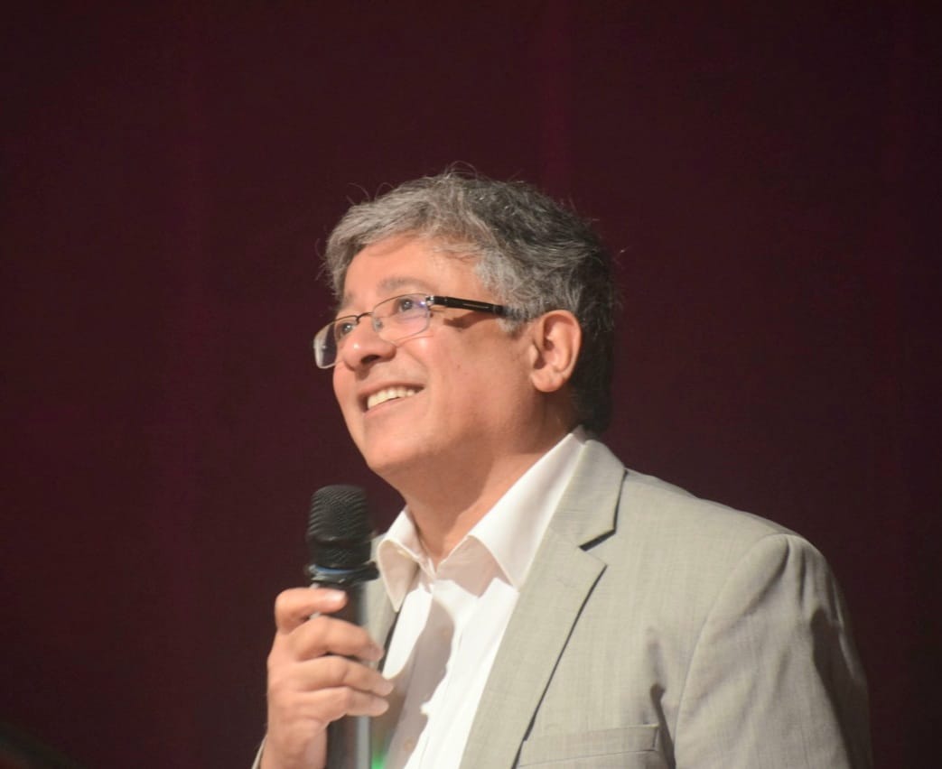
In an exclusive conversation with The Interview World, Vijay Dubey, Managing Director of Jomiso Consulting Pvt. Ltd., highlights the company’s core focus areas. He emphasizes how their solutions directly address farmers’ challenges, elaborates on the app’s effectiveness in flood mitigation, discusses the advanced technologies the company employs, and shares valuable insights into their clientele. Here are the key takeaways from his enlightening interview.
Q: What are the key focus areas of Jomiso Consulting?
A: In the water resources sector, our focus lies at the top end of the value chain, not merely because agriculture water falls under this category. When dividing the water sector into three key areas, the first is the top tier, where water originates—from river basin planning to irrigation canals. This is followed by municipal and industrial water, and lastly, the distribution segment.
We specialize in the top tier of this value chain, providing critical services such as water accounting, modeling, flood forecasting, reservoir operation management, and canal automation. Our software emerged in response to a significant challenge faced by the Government of India: the management of water levels, which is the most crucial data, traditionally relies on manual gauge posts. This system depends heavily on field personnel who report water levels every hour. However, there’s no current mechanism to ensure they’re providing readings from the actual gauge, rather than remotely from their homes.
For a river basin manager facing a flood situation, this reliance on manual verification is problematic. In an emergency, they must confirm the accuracy of readings multiple times before issuing alerts. Conversely, with our solution, a real-time photograph of the gauge is available, enabling immediate decision-making without delays. This capability is crucial in emergencies, allowing for swift action and timely warnings. This urgent need for accurate, real-time data inspired the development of our solution.
Q: How will your solution directly benefit farmers and address their most pressing challenges?
A: Farmers face significant challenges within the canal system due to widespread mistrust between water associations, canal authorities, and the farmers themselves. For instance, when the canal authority releases 100 cubic meters of water, farmers often claim that the water does not reach their fields. This mistrust arises because the canal authorities provide no evidence to back their claims.
Our solution addresses this issue by installing gauge posts at regular intervals of 5 to 10 kilometers along the canal. These posts, monitored by staff, measure the water level, enabling precise calculations of the water volume at various points in the canal system. This data becomes undeniable proof, accessible to both authorities and farmers. Farmers can view the water volume on a specific day and time through a mobile app, offering transparency and accountability.
By eliminating mistrust, this system ensures that farmers receive their fair share of water. It also prevents the need for costly and time-consuming court disputes, which waste the resources of both the water resource department and the farmers. The core idea is to create a system based on evidence, facilitating efficient decision-making and reducing conflicts.
As a canal operator, knowing the exact water delivery at every stage, for example, after 50 kilometers, becomes essential. If 100 liters are released and only 70 liters are recorded after 50 kilometers, the system enables an investigation into potential losses, whether due to theft, leakage, or other issues. This provides a comprehensive water budget for the canal system, empowering both operators and farmers to make informed decisions about irrigation timing and water usage.
Q: How does your app contribute to effectively managing and mitigating flood situations across the country?
A: In flood situations, water levels are measured in two ways: manually through gauge posts or automatically via electronic sensors. The current method for data collection in these systems reveals significant limitations. Sensors, while convenient, lack the ability to provide concrete evidence and can malfunction if not regularly calibrated.
The Central Water Commission’s flood forecasting largely relies on 1,568 manual gauging sites across India. They spend over 300 crores annually on outsourced staff salaries, who are responsible for reading these gauges in the field.
When we piloted our solution last year, we found alarming discrepancies. From June 1st to October 31st, during the monsoon season, readings are supposed to be collected every hour, and every 8 hours in the non-monsoon season. However, our pilot, conducted across 50 sites, revealed that none provided the required 24 readings per day. The maximum we received were 15 or 16 readings daily. This inconsistency indicates that India’s flood forecasting is fundamentally flawed.
Moreover, these outsourced staff are paid monthly, regardless of whether they provide accurate readings from the site or from home, making monitoring nearly impossible. Our tool was initially developed to enhance flood alert systems. We have since expanded its application to include canal monitoring, but the core idea was always centered on improving flood alerts.
Q: Can you provide a detailed explanation of the core technology that powers your solution?
A: The technology is straightforward but requires the application of computer vision algorithms due to the variability of gauge types. These gauges aren’t standardized. Some are painted on pillars, others on rocks, or even on bamboo sticks. This variability presents a challenge. For flood forecasters needing to issue warnings, having solid evidence is crucial.
To address this, we created a comprehensive system that tackles three primary issues. First, how do we monitor the performance of outsourced staff? Second, how can we ensure that the data received is both authentic and validated? Third, how quickly can we disseminate this critical information?
We solved these challenges through a mobile application. The first issue was tackled by requiring the gauge reader to take a photo of the gauge. This possible only within the vicinity of the gauge. If they are not nearby, the app will indicate that they are out of range. This ensures accurate geotagging of both the person and the gauge, effectively solving the first problem.
For the second challenge, the photo is captured even in areas with poor network coverage, such as riverbanks. Once the person moves 100 meters from the gauge, the photo is automatically sent via a 2G or 3G network to a web portal. This allows you, from your office, to monitor the water level in real-time, such as the Haridwar pool water level nearing a danger threshold. You receive three data points: the value entered by the person, the value generated by the algorithm, and the photo itself.
This redundancy ensures accuracy. If the person enters an incorrect value, even a small error, the system flags it. You can then verify the entry against the photo and take appropriate action, such as issuing an alert if the water level has indeed crossed the danger mark. Thus, the second problem is resolved.
Finally, the third issue concerns data archiving. Previously, only a single data point was available. Now, with three—photo, manual entry, and algorithmic entry—you can validate and cross-check historical data. If discrepancies arise, this system allows you to clear them, ensuring the integrity of the flood monitoring process.
Q: How many states are currently utilizing your solutions?
A: We are currently collaborating primarily with the Central Water Commission, the main agency responsible for flood forecasting. This agency relies on a manual system, which, despite being trusted, we aim to automate while preserving essential human input.
Human intelligence plays a critical role. For instance, as a gauge reader, I measure river levels and assess potential flood risks, breaches, and erosion. These data sets automate sensors alone cannot capture. By integrating human insights with technology, we ensure that critical observations like detecting breaches in riverbanks, are recorded alongside automatic data.
At Jomiso, our goal is not to fully automate the process but to support and enhance it with technology. We recognize that human expertise remains irreplaceable.

1 Comment
obviously like your website but you need to test the spelling on quite a few of your posts Several of them are rife with spelling problems and I to find it very troublesome to inform the reality on the other hand Ill certainly come back again
Comments are closed.