Can invention be systematized? PlaniN Lab, an IIT Delhi-incubated innovation lab, answers with a resounding yes. At the heart of its mission lies a process-driven, technology-agnostic framework that consistently transforms complex challenges into scalable inventions. Among its most ambitious pursuits is the vision of making Indian cities traffic-light-free. More importantly, the lab has already translated that vision into reality by deploying its solutions at live intersections and eliminating the need for traffic signals. Yet its impact extends far beyond mobility. A diverse portfolio of inventions and patents demonstrates the strength and versatility of its methodology across domains.
Looking ahead, PlaniN aims to build a lasting inventor-led ecosystem rather than remain a standalone lab. It seeks to embed physical planning into mainstream practice while encouraging engineers and designers to approach problems with an inventor’s mindset.
In an exclusive conversation with The Interview World, Founder Fani Bhushan discusses process-driven invention, AI-enabled planning, urban transformation, climate-resilient infrastructure, accountability, sustainability, and stakeholder coordination. Here are the key takeaways from his compelling conversation.
Q: What solutions does your company offer, how does physical planning differ from urban planning and DPRs, and can you share a representative case study?
A: PlaniN Lab operates as a diversified inventions lab with a structured, three-vertical portfolio that spans invention science, spatial engineering, and AI systems. Each vertical serves a distinct function, yet all converge on one objective: converting complex, real-world problems into implementable, measurable solutions.
First, the lab applies a TRIZ-led invention workflow to product innovation. This methodical framework systematically breaks down contradictions in problem statements and resolves them through structured inventive principles. As a result, the lab develops high-impact solutions across domains such as women and child safety, including panic-button architectures, cooling system designs, private instant-network storage, physical signature fraud prevention systems, and offline OTP mechanisms. These are not isolated concepts; they emerge from a repeatable invention engine designed to produce consistent outcomes across use cases.
Second, PlaniN works in physical planning, also described as city design. Here, the focus shifts from discrete products to full-scale urban systems. The lab designs signal-free interchanges, continuous mobility corridors, integrated bicycle and pedestrian networks, walkable streets, and end-to-end urban utilities including drainage, water supply, and solid-waste systems. In effect, it designs complete city geometry. However, listing outputs alone does not capture the value. The real differentiation becomes visible only when conventional approaches are compared side by side with these system-level spatial designs.
Third, the lab builds context-gated AI modules and training systems. These models do not operate in generic environments. Instead, they function within defined spatial, infrastructural, and operational contexts, allowing them to support planning, simulation, and decision-making with higher relevance and precision.
To understand this work, one must distinguish three layers. Urban planning historically evolved to allocate land across competing uses and to define regulatory frameworks. It produces master plans, zonal plans, and development control regulations. In contrast, a Detailed Project Report (DPR) serves as an execution document. It translates a pre-decided project into administrative and technical specifications. It does not redesign the city; it only operationalizes intent.
Physical planning fills the critical gap between these two. It converts city intent into precise engineering geometry, service benchmarks, cost logic, design alternatives, and phased implementation pathways. It defines what should be built, why it should exist, and how it should perform before execution begins.
In practice, infrastructure briefs in India often remain overly broad. A highway may simply be described as a six-lane corridor from point A to point B. This ambiguity limits downstream quality. By contrast, complex systems demand detailed definition upfront.
A useful analogy lies in home design. No architect receives only the instruction to build a three-bedroom house. Instead, they study lifestyle, family structure, long-term needs, constraints, and budgets before producing a design. Cities deserve the same rigor.
Physical planners perform this translation for society as the client. They convert collective needs into spatial definitions, measurable outputs, and implementable design logic. This discipline already exists formally within institutions such as the School of Planning and Architecture, which has taught physical planning as a core field since 1989.
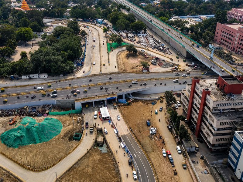
A practical illustration appears in the Bailey Road–Lohia Path Chakra in Patna. The intervention eliminated congestion across nearly fifty access points without land acquisition or demolition. It resolved drainage, waterlogging, and metro integration simultaneously. Travel time reduced by over ten minutes, and traffic efficiency improved substantially. Importantly, the design achieved this using two directional half-loops instead of a conventional cloverleaf, reducing land requirements by more than 70 percent. Spatial logic led; engineering execution followed.
Q: Urbanization is accelerating across many regions. How can AI-powered planning tools help cities deliver critical infrastructure faster while maintaining quality, sustainability, and public accountability?
A: Delivery slows and quality deteriorates when project scope remains vague and service levels are not explicitly defined. The problem deepens when teams do not iterate enough to refine solutions toward optimal outcomes. It worsens further in the absence of an integrated, forward-looking solution architecture. Poor coordination, low transparency, and fragmented, sector-specific thinking reinforce these inefficiencies. In such an environment, adding AI does not resolve structural flaws; it only accelerates flawed assumptions and produces incorrect outcomes faster.
Cities are also evolving in scale and complexity. They are becoming denser, more interconnected, and increasingly layered systems. Therefore, physical planning must sit at the foundation of decision-making. It must define spatial logic, functional intent, and engineering structure before any analytical or digital system is applied. Only then can AI tools operate effectively, supporting planners with data processing, forecasting, and faster iterative evaluation.
When correctly deployed, these systems expand design possibilities instead of narrowing them. They enable comparison across multiple alternatives rather than locking projects into early-stage decisions. They also reveal hidden conflicts before they are embedded into Detailed Project Reports. For instance, foundation designs may later clash with unplanned metro alignments in the same corridor, creating avoidable structural conflicts.
A robust planning framework resolves this by enabling structured iteration, integrated system design, and transparent, traceable decision-making from concept to execution.
Q: Sustainability has become a core requirement in urban development. Can AI-driven project planning help cities reduce environmental impact, optimize resource utilization, and support climate-resilient infrastructure?
A: Intelligence must enter at the point of conception, not after design decisions are locked. AI remains a tool; it does not define intent. Human imagination must set purpose, especially when the objective is human-centric cities and improved quality of life. Once a project is frozen, sustainability turns into compromise. At the concept stage, however, it can guide every choice. The greatest impact emerges when mobility, utilities, land use, climate, cost, resource consumption, and construction impact are evaluated together rather than in isolation.
Physical planning enables this integration by structuring interconnected urban systems into a coherent framework. It allows planners to test interdependencies before execution begins. AI then amplifies this process by simulating large-scale, integrated scenarios and accelerating iteration.
The results are tangible. Material use drops through reduced cement and steel requirements. Land efficiency improves. Drainage systems become more resilient. Pedestrian networks become safer and more continuous. Public mobility aligns better with urban form. Infrastructure responds to climate rather than resisting it. Collectively, these gains translate into measurable improvements in urban performance and quality of life.
Q: Many urban projects involve multiple stakeholders, including government agencies, contractors, consultants, and local communities. How does PlaniN Lab improve collaboration and decision-making among these diverse groups?
A: Poor collaboration is rarely the root cause. It is a downstream symptom of a broken information system. It appears when stakeholders lack a shared, standardized language. It also emerges when critical information does not reach the right actor at the right moment. Fix these two gaps and most coordination friction collapses.
Collaboration improves immediately when everyone frames the same problem through the same lens. However, in practice, government agencies, consultants, contractors, and communities often interpret the same project differently. That divergence becomes the source of most disputes. To eliminate it, we place all stakeholders on a common data environment that is structured, visual, and continuously shareable. A 3D physical model or an open BIM or digital twin layer communicates intent far more effectively than fragmented 2D engineering drawings, especially for non-technical stakeholders.
More importantly, we do not only present outcomes. We expose reasoning. We show the proposal, the alternatives considered, and the rationale for rejecting each option. We also clarify expected impacts upfront. When logic becomes visible early, decisions accelerate. Transparency increases. Accountability strengthens. As a result, collaboration shifts from negotiation under ambiguity to alignment under shared understanding.
Q: Data quality is often a challenge in large infrastructure projects. How does your platform ensure that AI-generated recommendations remain reliable and actionable when project data is incomplete or constantly changing?
A: We do not treat AI as an independent authority. This is intentional. Indian cities face persistent data gaps and quality issues. Therefore, every AI-generated output must undergo domain expert validation and ground verification before use.
We build intelligence incrementally, one context at a time, starting with high-stakes areas such as safety and mobility. We avoid a single generalized model and instead develop context-specific systems shaped by local realities.
As a result, human judgment remains central. Accountability stays with professionals, not algorithms. Incomplete or evolving data further strengthens the need for expert oversight. It does not justify automation of decisions; it demands closer integration between computation and human reasoning.
Q: Looking ahead, what is your vision for PlaniN Lab’s role in shaping the next generation of urban development, and what impact would you like the company to have on cities globally?
A: I aim to reshape how Indian cities are designed by embedding physical planning as a core methodology. I also aim to help cities move toward traffic-light-free mobility systems and ultimately rank among the world’s most walkable, clean, safe, enjoyable, and investment-attractive urban environments. Mobility, safety, water stress, air quality, women and child safety, drainage, and public transport are not isolated challenges. They are spatially interconnected. Therefore, they must be solved within a unified physical framework.
My experience in strategic planning at Bank of America strengthened my approach to scale, risk, forecasting, error analysis, and measurable decision-making. At the same time, exposure within the IIT Delhi ecosystem, including advanced work in cryogenics and quantum computing environments, reinforced a first-principles approach to complex problems. PlaniN channels this synthesis into invention-led, execution-ready physical planning for cities.
We believe this mobility and safety architecture will, over time, influence urban systems globally.